Andrew Wiens - Study Abroad SU10
Contents
About the Trip
Albert Einstein once said, "Israel can win the battle for survival only by developing expert knowledge in technology." As we learned, the Technion, located in Haifa, Israel, was conceived largely to realize this ambition; it is the oldest technical institution for higher learning in that part of the world. Over the years it has grown from its humble roots in downtown Haifa to become the heart of Israeli technology and industry. As a lowly undergraduate who just finished his freshman year, being invited to the Technion halfway around the world was no small matter.
Our visit to the Technion, covering five days of the trip, introduced us to nearly every engineering department at the university. The departments of Electrical, Mechanical, Aerospace, Computer Science, and Biomedical Engineering were among those that we had the privilege to see. Professors, students, and researchers presented their departments’ projects and academic disciplines with slide show presentations and live demonstrations. Projects at the Technion ranged from flying quadcopters to surgical aids, from “fire-fighting” robots and hexapods to bipedal robots and UAV airplanes. As we learned, such tangible engineering projects are a staple of an undergraduate education at the Technion.
In addition to learning about engineering at the Technion, we also actively participated in engineering during our many lab sessions. We used methods and concepts such as proportional-integral-derivative algorithms to solve problems such as balancing a pole with an electronic stepper motor. Other labs served more as an overview of a specific area of signal processing by introducing us to areas such as audio signal processing and speech synthesis.
On the whole, the trip inspired me to seek out my own independent study project. Although we do have the senior design projects at the end of our undergraduate careers here at Washington University, students at the Technion often complete two or more research or design projects as undergraduates in addition to working 15+ hours a week in industry! In light of this it seems that, rather than distracting from an education in electrical engineeirng, engaging in self-motivated projects can be a rewarding experience that enhances and expands students' knowledge of electronics and real-world problem solving.
Further Research
While visiting the Technion we saw a few helicopter projects. One project, which was completed by a team of two undergraduate students, was a remotely controlled quadcopter utilizing four vertical propellers to generate lift and control. Another project, which was an ongoing research project conducted by graduate students, faculty members, and lab technicians, was a single-rotor helicopter designed to autonomously follow and track a land-based vehicle with a target application for urban law enforcement situations. In order to understand these projects better the devices and methods used to localize an unmanned helicopter’s position must first be investigated.
UAV Design – Sensors for Object Avoidance with Unmanned Helicopters
There are many problems encountered when designing a robotic helicopter. First, a stable, airworthy helicopter platform must be designed. This task alone encompasses a vast range of disciplines including materials, mechanics, control, structure, and aerospace engineering. Luckily, there are many commercial small-scale helicopter platforms available on the market, the use of which relieves the electrical engineer from the task of designing the helicopter platform. Once a worthy helicopter platform is obtained, control and navigational systems must be designed to enable the robot to travel about its environment. The focus of this report is on the latter and explores the use of various types of sensors to provide object avoidance for a small-scale autonomous robotic helicopter.
Ultrasound
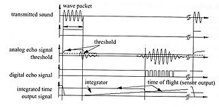
Ultrasonic sensors are one means to enable the robot to determine its distance from nearby objects. Ultrasonic distance sensors operate by the time-of-flight paradigm: a wave packet is emitted from a transmitter and the onboard computer waits to hear the packet echoed back to a receiver. Using the difference between the time of arrival and the time of transmission, the distance can be calculated based on the speed of sound.
This technique poses a few problems. First, because the speed of sound is relatively slow, the propagation time of the ultrasonic waves is quite high leading to a slow refresh rate. For example, finding the distance of an object that is only three meters away with a single ultrasonic sensor takes twenty milliseconds resulting in a refresh rate limited to 50 Hz.
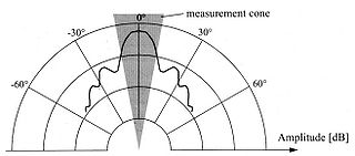
Additionally, the attenuation of ultrasonic waves in air is quite high and results in a low effective distance; typical robotic ultrasonic sensors have a range of no more than five meters. Also, ultrasonic waves propagate in a cone-like shape and cannot be used to determine the distance of a small point. Thus, the sensor’s spacial resolution decreases as the object’s distance increases until the distance is large enough to render the sensor unusable.
Laser
Laser rangefinders rely on the same theory as ultrasonic sensors to determine distance from time-of-flight of a wave. They are similar in principle: laser rangefinders, or lidars, use electromagnetic light while ultrasonic sensors use high frequency sound. However, since the attenuation of light in air is much less than ultrasound, the range and resolution of lidars is much better than their ultrasonic counterparts. Additionally, because the speed of light is much faster than the speed of sound, the turnaround time for lidars is much faster than ultrasonic sensors. This enables the use of mirrors to generate two- and three-dimensional maps in realtime.
Lidars do have a few drawbacks, however. First, lidars only work when the light is diffused off of the reflecting surface. Thus, polished surfaces such as glass and mirrors will yield improper results from lidar sensors. Small scale helicopters are likely to encounter such surfaces since they are often used in indoor applications and thus lidar sensors cannot be used alone. Additionally, although commercially available lidars have successfully been used with much success on robots in applications such as the DARPA autonomous land vehicle competitions, lidars may be too large and heavy to be used on small-scale helicopters.
1D Optical
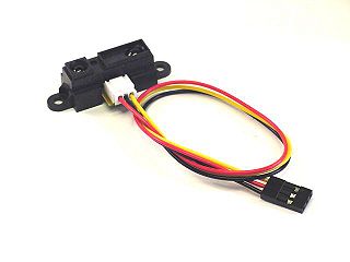
Distance sensors using one-dimensional optical triangulation provide simple one-dimension range information. The paradigm these use provides similar functionality as the time-of-flight ultrasonic sensors. They provide simple one-dimensional range information, and have limited range making them useful primarily in short-range situations. However, the concept they use is very different from the ultrasonic sensors.
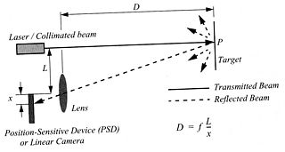
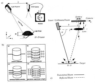
Rather than calculating the time-of-flight of a transmitted wave, 1D optical sensors utilize optics to bend light. To do this, a typical 1D optical sensor utilizes an infrared LED, a lens, and a small linear camera. The LED projects an infrared beam onto the object while a lens focuses the returning light onto a linear camera. The horizontal position of the reflected light on the linear camera changes as the vertical distance between the sensor and the object changes. This provides a simple one-dimensional distance measurement.
These sensors have the benefit of low cost and simplicity; however, due to the fact that the lens and linear camera are of a finite size they are limited in range. Also, since the distance between the sensor and the object is inversely proportional to x, the position of the light incident on the linear camera, their resolution suffers as the distance to the object increases.
2D Optical
Replacing the linear camera with a two dimensional CMOS or CCD image sensor results in a distance sensor that can determine the distance to a large set of points rather than just one. By projecting a known pattern onto the surface of the object, such a sweeping laser stripe using a laser and a prism, the image captured by the CMOS or CCD sensor can be filtered in software to determine the distance to multiple objects. This technique is highly effective in multiple scenarios, including instances where the surface is featureless, and can be used as an alternative to lidar sensors.
