Difference between revisions of "3D Mapping with Infrared Sensors 2010"
From ESE497 Wiki
Jump to navigationJump to search| (3 intermediate revisions by one other user not shown) | |||
| Line 14: | Line 14: | ||
**Week 6 | **Week 6 | ||
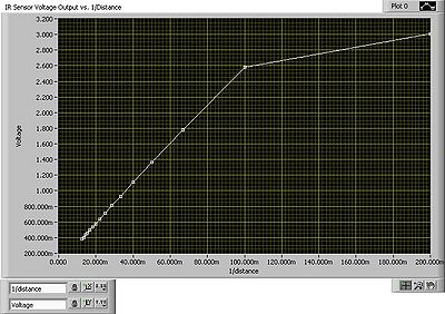
[[File:Vertical_to_be_posted.JPG|400px|IR Sensor Voltage Output vs. 1/Distance]] | [[File:Vertical_to_be_posted.JPG|400px|IR Sensor Voltage Output vs. 1/Distance]] | ||
| − | **Week 7 | + | **Week 7 - Video |
| − | [[media:LisaGoldman_FL10_DSL720x480.wmv| | + | ***[[media:LisaGoldman_FL10_DSL720x480.wmv|LisaGoldman_FL10_DSL720x480.wmv]] |
| + | <video caption="LisaGoldman_FL10_DSL720x480.wmv">LisaGoldman_FL10_DSL720x480.wmv</video> | ||
**Week 10 | **Week 10 | ||
| + | ***[[Final_Report.docx|Final_Report.docx]] | ||
Latest revision as of 05:12, 20 December 2010
- Team Members: Lisa Goldman
- PhD Supervisor: Bill Feero
- Faculty Supervisor: Arye Nehorai
- Goal: To create a digital map of any obstacles within an 80 cm radius using IR sensors and the SbRio robot.
- Meetings
- Thursday 8:30 AM - 10:00 AM
- Status
- Week 1
- Week 2
- Week 3
- Week 4
- Week 5
- Week 6
- Week 7 - Video
<video caption="LisaGoldman_FL10_DSL720x480.wmv">LisaGoldman_FL10_DSL720x480.wmv</video>
- Week 10
